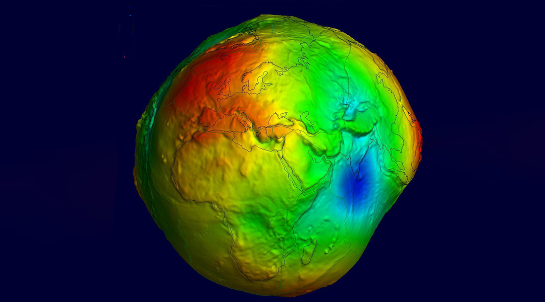
In the middle of the Indian Ocean lies a gravity hole, the origin of which has puzzled scientists since its discovery in 1948.
While we often think of Earth as a perfect, rotating sphere, the truth is that the surface of our planet is quite irregular — flattened at the poles and bulging at the equator, not to mention the varying topography of peaks and valleys spread all over its surface.
These variations cause changes in gravity’s pull at different locations, giving rise to a geoid, an imaginary sea level surface that undulates all over the Earth. The majority of gravitational variations can be explained, but scientists have not been able to explain how this 3 million square kilometer depression came to be.
Compared to its surroundings, the gravity there is so weak that sea level at this location is 106 meters lower than the global average.
“The origin of this geoid low has been enigmatic. Different theories were put forward to explain this negative geoid anomaly,” wrote geophysicist Debanjan Pal and doctoral student Attreyee Ghosh from the Indian Institute of Science in Bangalore in a paper published in Geophysical Research Letters. “All these studies looked at the present-day anomaly and were not concerned with how this geoid low came into existence.”
To get an answer, instead of looking at the geological processes taking place inside or under the gravity hole, or geoid low, itself, as previous studies have done, the duo looked at what was happening around it. They began with 19 computer models, all set up with varying parameters, and simulated how the Earth’s tectonic plates may have been moving around this low over the last 140 million years.
They compared the models’ outputs to observations of the geoid low as it is today, and those that matched up all had one thing in common: low density plasma plumes wafting up from below the low.
India and Australia were once part of the southern super continent, Gondwana, which began to break apart roughly 100 million years ago. As the Indian tectonic plate migrated north toward the European plate, it advanced over the ancient seabed of an ocean called the Tethys Sea, which sank into the Earth’s mantle, giving way to the Indian Ocean behind it.
Part of the Tethys seabed can still be found in the Mediterranean. However, most of it is slowly melting deep in the Earth’s interior around Eastern Africa. As the dense mantle melts away, it creates the plumes of low-density magma that pull the surface down. Compounding the effect is the fact that surrounding masses, such as the Tibetan plateau, create a gravity high, amplifying the effect.
“With realistic plate motion history we are able to reproduce a reasonable match with the observed seismic velocity anomalies in the Indian Ocean region,” wrote the team. “Our results demonstrate that in addition to plume-derived hot material pooling in the upper mantle in the northern Indian Ocean, hot anomalies below 1,000 km (e.g., African LLSVP) are also responsible for this geoid low.”
While the results are consistent with Ghosh’s previous modeling work published in 2017, not everyone is convinced and hard evidence will only confirm this thoery. To confirm their predictions, scientists will need to provide evidence of the plumes using earthquake data collected from around the geoid low.
Reference: Debanjan Pal and Attreyee Ghosh, How the Indian Ocean Geoid Low Was Formed, Geophysical Research Letters (2023). DOI: 10.1029/2022GL102694
Feature image credit: Geoid undulation in false color. (International Centre for Global Earth Models/Wikimedia, CC BY 4.0)


